
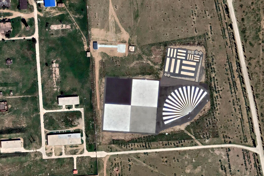
We do not see them; they are hidden all around us, out of sight, and only visible from the sky. They are giant “QR codes” whose existence is unknown to most. And yet hundreds of them appeared from the 1930s onward in various points around our old planet.
These “giant QR codes” that have dotted the planet for more than 80 years are not messages for aliens nor a joke. They are the silent infrastructure that allowed calibrating aircraft and spy satellites’ cameras during much of the 20th century and that today continue to serve that purpose.
Geometric Figures for Calibration
Google Earth brought them to light starting in 2011, when thousands of users began tracing deserts and military bases in search of enigmatic geometric shapes. Concrete crosses, wind roses of vast scale, and zigzagging white grids appeared all over the world, from Arizona to the Gobi Desert, and also in Europe.
The most photographed is the wind rose at Edwards Air Force Base, California, painted on the dry lake bed of Rogers Dry Lake. It has a diameter of 1.22 kilometers, is regarded as the largest in the world, and serves as a reference for pilots to land even if their navigation equipment fails.

Wind rose at Edwards Air Force Base, California.
The mark does not date from the 1930s, as is often repeated: the magnetic declination recorded in the symbol matches the value of the Earth’s magnetic field at that point in 1956, the actual year of its construction, according to measurements made with Google Earth’s own tool. It was designated a National Historic Landmark in 1985.
In that same base there appear other marks known as “tri-bar.” They are groups of white bars of decreasing size where the smallest bar the satellite could distinguish indicated the system’s resolution limit.
The most cited case, and the most poorly explained, is the set of concrete crosses at Casa Grande, Arizona. For years their construction was attributed to calibrating the Corona spy satellites, but the real origin is different.
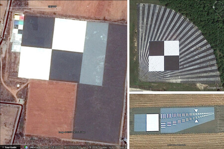
On the left, one of the few calibration structures that uses color. It is Shadnagar, India. Upper right, at NASA’s Stennis Space Center in Mississippi. Bottom right: the one at Travis Air Force Base, USA.
They were part of the Casa Grande Photogrammetric Test Range, a grid of 272 concrete markers spread over an area of 26 by 26 kilometers, erected in the mid-1960s by the U.S. Army Map Service to calibrate aerial photogrammetry cameras, not orbital equipment.
At the other end of the world, in the Gobi Desert, between the Gansu and Xinjiang provinces, grids of white lines painted appear that do fulfill the function that urban legend wrongly attributed to the Arizona crosses: calibrating the cameras of China’s spy satellites, according to analysis by Jonathon Hill of the Mars Space Flight Facility at Arizona State University. The size of these grids, larger than expected, suggests that the resolution of those cameras was at that time more limited than that of their Western counterparts.
Today, some of these giant “QR codes” are still in use. And while the resolution of spy satellites, and non-spy satellites, has massively improved in recent years, they still require calibration.
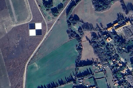
The black-and-white squares at the Armée de l’Air et de l’Espace base in Salon-de-Provence, France.
Although these satellites “are well designed and calibrated before launch, they require ongoing calibration to compensate for degradation that may be caused by mechanical or electrical effects, or exposure to ultraviolet radiation. Calibration demands a comparison between the measuring instrument and an absolute reference pattern of known precision,” explain the United States Geological Survey.
Europe has its own example, not far from home. At the French airbase of Salon-de-Provence, historic home of France’s Patrol, a checkerboard of white and black squares is visible from the air. It is “a fundamental resource for the calibration and validation of remote sensing instruments,” according to the USGS ECCOE (Calibration and Validation Center for Earth Observation) platform at the Earth Resources Observation and Science Center.
Thus, the airbase “features a target pattern of four squares, each 30 meters on a side, with the overall axis of the target rotated three degrees west from true north. This geometric configuration provides high-contrast edges essential for evaluating spatial resolution and the geometric accuracy of satellite sensors.” All this to assess image sharpness and the performance of optical systems.
All these marks share a common logic. Before trusting an image taken hundreds of kilometers high, whether by a spy satellite, navigation satellites, or weather observation satellites, a fixed ground reference is needed against which to compare the images. What in 2011 seemed like a Google Earth mystery was, in fact, the fine print of the space race and satellite surveillance of the 20th and early 21st centuries.
Images | Google Earth