
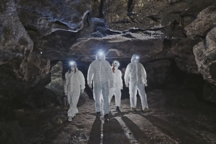
When thinking about maps or topographic models of a landscape, we usually associate them with satellites, GPS systems, digital mapping, or 3D representations. Yet a group of archaeologists has discovered that many (many) thousands of years ago humans were already trying to understand and depict the surrounding terrain. One of the most striking examples is found in a small cave in the southern outskirts of Paris.
The cave of Ségognole 3, in the Noisy-sur-École sandstone massif, has long been known for its Paleolithic engravings, until a study published in late 2024 in the Oxford Journal of Archaeology changed everything. It presents a fascinating hypothesis: about 20,000 years ago several hunter-gatherer groups deliberately transformed the cave floor to miniature-scale reproduce the relief and the water behavior of the surrounding landscape. In this way, they may have created the first map in history.
A Landscape Model Integrated into the Rock Itself
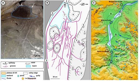
What makes this finding unique compared to other possible prehistoric maps found on portable pieces or two-dimensional engravings is that the representation at Ségognole 3 is embedded directly into the terrain. This was documented by researchers Médard Thiry, of Mines Paris PSL, and Anthony Milnes, of the University of Adelaide, who identified a complex network of carved channels that take advantage of natural cracks and undulations in the sandstone.
Remarkably, those grooves run along small slopes, depressions and reliefs that correspond to the geomorphological features of the École river valley, located just about 500 meters from the cave. According to the authors of the discovery, those shapes would represent “watercourses, lagoons, basins and elevations of the terrain” at scale.
As if the finding by itself were not enough, the most striking detail of this “three-dimensional map” comes to light when it rains: water seeps through its small cracks and travels through the carved channels following paths very similar to those of a real river system. For the researchers, the whole ensemble works as a sort of miniature hydraulic model capable of reproducing the natural behavior of water over the landscape.

In their publication, the authors argue that this level of precision demonstrates “an enormous capacity for observation and spatial abstraction by those Paleolithic groups.” Beyond a thorough understanding of the territory in which they lived, they were able to physically translate it onto a surface by using the natural relief of the rock.
A Place Rich in Symbolism That Still Raises Questions
The cave of Ségognole 3 also contains horse engravings and female representations associated with the Upper Paleolithic, bearing stylistic similarities to the paintings at Lascaux. Part of the water guided by the channels also ends in a vulva-shaped cavity, a detail that has led researchers to connect the assemblage with ideas of fertility, water, and ritual symbolism.
Nevertheless, scientists remain cautious about the definitive interpretation of the site, since they deem it unlikely to have served as a practical navigation aid, given that the landscape could be easily observed from the nearby hills. Among the proposed hypotheses are possible pedagogical uses related to water, ceremonial functions, or symbolic representations of the territory.
Beyond whatever its exact utility was, Ségognole 3 stands as a remarkable demonstration that 20,000 years ago humans were already capable of interpreting the landscape and representing it in a manner far more complex than previously thought.
Images | Média24, Médard Thiry