
In Brief
In India, along NH‑45 as it runs through the Veerangana Durgavati Tiger Reserve, an innovative stretch has been inaugurated: a wildlife-safe road featuring a striped red surface. This setup aims to slow motorists through color, vibrations, and noise, without relying on speed bumps. Fences and underground passages accompany the initiative to channel wildlife movement and keep their routes secure. Cameras and sensors monitor speeds and animal usage, with the goal of coexisting with nature and preserving ecosystems. The project, still recent, stands as a large‑scale, real‑world test for road safety and animal protection.
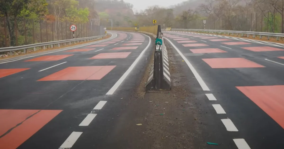
A road that turns bright red in the middle of the forest, with a textured, striped surface that vibrates under tires… No, this isn’t a video game backdrop, but a real highway segment in India designed to compel drivers to ease off, while giving wild animals living just meters from the asphalt a chance to roam.
Vehicle–animal collisions aren’t confined to remote rural areas. A Pew Charitable Trusts study estimates that in the United States, between 1,000,000 and 2,000,000 crashes involving large wildlife—like deer—occur each year on roughly 4,000,000 miles of roads, about 6.4 million kilometers. It’s a global phenomenon, and India answers with a spectacular approach: on National Highway 45, in the state of Madhya Pradesh, a stretch crossing the Veerangana Durgavati Tiger Reserve has been transformed into a red-striped, “wildlife-safe” road designed to slow vehicles and protect wildlife. What a driver experiences entering it is hardly a routine highway experience.
In India, a Red Road That Forces Drivers to Slow for Wildlife
Every region has its emblematic wildlife and its own set of risks: moose in Maine, kangaroos in Australia… In India, tigers, monkeys, or even cheetahs may find themselves near, or right in the path, of roadways. National Highway 45 is a major artery connecting several key zones of the country, and a 7‑mile-plus segment—just over 11 kilometers—winds through the Veerangana Durgavati Tiger Reserve. It is here that authorities identified a “danger zone” where wildlife presence is especially high.
Over roughly 1.2 miles, almost 1.9 kilometers, the plain asphalt strip gives way to a striped red coating. Each segment sits about five millimeters higher than the surrounding surface. The driver not only sees the color clearly but also hears and feels it: tires produce a duller noise, and fine vibrations travel up through the steering wheel and seat. Speed sensors embedded in this system detect excess speed; at higher speeds, the vehicle “doesn’t roll smoothly,” and the discomfort becomes noticeable, nudging the driver to ease off without the need for hard-to-cross speed bumps.
This red marking isn’t arbitrary. It takes inspiration from red-painted speed zones on Dubai’s Sheikh Zayed Road, where the color already serves as a highly visible danger cue amid traffic. Here, the aim is to go further: color the pavement to remind drivers that they are passing through a living habitat, while using texture to trigger an immediate physical response. The Indian Ministry of Transport summarizes the philosophy behind this approach, explaining: “A pioneering safety initiative implemented on a stretch of a national road crossing a sensitive forest and ghats shows how road engineering can balance human safety, wildlife protection, and ecological preservation, without compromising any of these three objectives,” the ministry notes, cited by Jalopnik. That sentence places this “wildlife-safe road” within a broader strategy of road engineering designed to coexist with nature.
Red Stripes, Fences, and Underpasses: a Corridor Built for Animals Too
Painting and striping the road isn’t enough to save tigers or monkeys if they keep crossing haphazardly. Authorities therefore combined several tools. On either side of the pavement, metal fences rise about eight feet tall (roughly 2.4 meters) to block direct access to the asphalt. In theory, these barriers keep wildlife away from the road. In practice, a tiger can leap up to 16 feet (about 4.9 meters), and a monkey can climb with surprising agility. A 2.4‑meter barrier is therefore not an impenetrable wall.
Its real purpose lies elsewhere: guiding movements. Along this roughly 7.4‑mile long segment (about 11.9 kilometers), animals are directed toward 25 underpasses built beneath the road. These underpasses provide safe crossing points, preserving hunting territories and migratory routes without forcing animals to confront traffic. In the areas with higher animal traffic, solar installations power the lighting, avoiding the need to run long electrical lines across the forest, which would pose additional risks to the local fauna.
- the striped red bands that entice drivers to slow down,
- the fences that steer animals away from the roadway,
- the 25 underground passages that give them a discreet crossing beneath the road.
Together, they form a corridor that aims to change human behavior as much as it guides animal movement. Cameras and speed sensors placed along the red section enable monitoring both the speeds in use and the animals’ actual use of the crossings. Engineers acknowledge there is no miracle solution: no barrier or marking alone can guarantee there will be no collisions. The goal is to multiply the layers of protection, for drivers and wildlife alike.
But a lingering question remains, one the Indian authorities themselves pose: does this “wildlife-safe road” actually work? The project is new, and it will take years of data to measure changes in wildlife–vehicle collisions, average speeds in the red zone, and usage rates of the underground crossings. Elsewhere, the concept of wildlife crossings has gained traction: roughly 1,500 animal-crossing structures exist in the United States across 43 states. Jalopnik notes, however, that a striped red surface like the NH 45’s would be hard to maintain in places where snowplows scrape off the top layer of asphalt each winter. In milder climates, though, this red road—as a constant reminder that travelers are passing through a living ecosystem—feels like an outdoor laboratory.
Comparison Table
| Element | Value |
|---|---|
| Length of the striped section | 1.2 miles (1.9 km) |
| Fence height | 8 feet (2.4 m) |
| Maximum tiger jumps | 16 feet (4.9 m) |
| Number of underground crossings | 25 |
| Length of the protected segment | 7.4 miles (11.9 km) |
| American wildlife-accident study metric | 1,000,000–2,000,000/year on ~3.98 million miles |
| Number of US wildlife-crossing structures | ~1,500, across 43 states |
| Raised-surface thickness | 5 mm (~0.2 inches) |
Key Takeaways
- A section of NH‑45 in India uses a striped, raised red surface to compel drivers to slow down without speed bumps.
- The project aims to reduce vehicle–wildlife collisions, particularly with tigers, in a reserve traversed by the highway.
- Eight-foot (2.4 m) fences channel animals toward 25 underground crossings to secure their movements.
- Sensors and cameras monitor speeds and how frequently wildlife uses the crossings.
- The initiative is being tracked over the long term to evaluate its effectiveness for road safety and ecological preservation.
FAQ
How does the red road protect tigers?
The road uses a striped red surface that emits vibrations and noise, prompting drivers to slow down without relying on speed bumps.
How many underground crossings were built for wildlife?
Twenty‑five underground crossings have been built under the road to allow wildlife to cross safely.
Do the fences really prevent animals from crossing the road?
The 2.4‑meter fences mainly serve to channel animals toward the underground crossings; they are not an impassable barrier.
What is the main objective of this “wildlife-safe road”?
The goal is to reduce collisions between vehicles and wildlife by altering driver behavior and guiding animals.
Has this setup proven its effectiveness yet?
The project is new, and it will take several years to assess its real impact on accidents and wildlife conservation.